Benham Plateau and the potential source of Petroleum/Natural Gas Deposits.
Benham Plateau
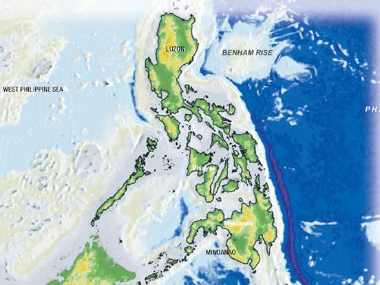
Benham Plateau (coordinates:  17°N 125°E / 17°N 125°E / 17; 125Coordinates: 17°N 125°E / 17°N 125°E / 17; 125), also known as the Benham Rise, is a seismically active undersea region and extinct volcanic ridge east of the Philippines, in the Philippine Sea. Under the Philippine Sea lies a number of Basins including the West Philippine Basin (WPB) of which inside the Basin is located the Central Basin Fault (CBF). The Benham Plateau is located in the CBF and its basement probably represents a micro-continent. Several scientific surveys have been made on the feature to study its nature and its impact on tectonic subduction, including one about its effects on the 1990 Luzon earthquake, which devastated the northern city of Baguio. The area is currently claimed, as part of its continental shelf, by the Republic of the Philippines, which has lodged a claim with the United Nations Commission on the Limits of the Continental Shelf on April 8, 2009.
The origin of the landform, along with a fellow landform, the Urdaneta Plateau (a remnant of mantle plume), is identified in one study as at least five sequences of propagating rifts, probably triggered by mantle flowing away from the mantle thermal anomaly. Its presence of the landform disrupts the continuity of this region (known as the Philippine-East Luzon Trench) by continuously colliding with the Sierra Madre mountain range of eastern portion of the island of Luzon. Though it is generally thought that the Philippine Sea Plate is being subducted under the Philippine Mobile Belt, under the rules of tectonic subduction, there appears to be a resistance to this because of the presence of the landform, and instead, the plate is being displaced into the northern portion of Luzon to the west.
The geophysical features of the plateau may have been the result of an early Miocene collision event between the Benham Rise and the eastern margin of Luzon, which may have also allowed the inception of the NW striking strand of the Philippine fault. These forces may have impacted the shape of the island of Luzon because of the basaltic sea floor resisting the subduction that may have also cause the bending of the Philippine Fault. The active basins in Central Luzon, which trace an asymmetrical V shape, is the best place to observe recent tectonic evolution of the fault system.
Philippine claim
Despite its proximity to the archipelago, the plateau was previously not included in the territory of the Philippine Islands. On 8 April 2009, the Republic of the Philippines lodged a partial territorial waters claim with the United Nations Commission on the Limits of the Continental Shelf in relation to the continental shelf in the region of Benham Rise. It was submitted as part of petition expanding the archipelago's baselines and exclusive economic zone through a law that also included other claims involving disputed territories of the Kalayaan Islands (Spratly Islands) and Scarborough Shoal. Although the landform, in itself, is not disputed, the petition still received some criticism inside and outside the country because of its controversial nature. According to the government's claim, based on a set of guidelines by the Commission on the Limits of the Continental Shelf, the area satisfies the 350-mile constraint line since the outer limits of the continental shelf are located landward of the constraint line, which is located 350 miles from the baselines where the measurement of the breadth of the territorial sea begins.The Congress of the Philippines enacted Republic Act No. 9522, also known as the Archipelagic Baselines Law, which is the basis of the claim. According to the document the region is bounded by the Philippine Basin on the north and east, and by Luzon on the west and south. It asserted that, according to scientific data based on seismic, magnetic, other geological features, the Benham Rise is an extension of the Philippines’ continental shelf. In summary, the baselines, the basis used for delineating the maritime territorial and jurisdictional zones (including the continental shelf), conform with the requirements of the UN Convention of the Law of the Sea (UNCLOS). The claim is only a partial claim since the law that allows the Philippines to expand its territorial boundaries also includes islands in the South China Sea.
Related Article of Benham Plateau:
Philippines may soon own vast gas-rich area - Benham Rise
16 Aug 2011
The Philippines will gain 13 million hectares in additional territory, an area slightly smaller than Luzon, should the United Nations approve next year the government’s claim on a region off the coast of Isabela and Aurora, Environment Secretary Ramon Jesus Paje said on Monday.
 Paje said the undersea region, called Benham Rise, could turn the Philippines into a natural gas exporter because of the area’s huge methane deposits. Studies conducted by the Department of Environment and Natural Resources (DENR) for the past five years indicate large deposits of methane in solid form, Paje said after a Senate budget hearing.
The government is only awaiting a formal declaration from the UN Convention of the Law of the Sea (Unclos) that Benham Rise is on the country’s continental shelf and therefore part of its territory, Paje said.
Legal basis
Once the Unclos establishes that Benham Rise is part of the Philippines, 'we would have legal basis to enter into exploration agreements with private companies to explore… (the area’s) resources,' said Sen. Franklin Drilon, chair of the chamber’s finance committee. Drilon said a favorable Unclos declaration would mean 'increasing our territory from present 30 million hectares to possibly 43 million' with the inclusion of Benham Rise.
Discussion over Benham Rise generated excitement especially after Paje said that Philippine representatives were just awaiting one more meeting 'to answer questions' before a special Unclos committee.
Only claimant
Paje said there was no reason for the Unclos committee not to issue a decision favorable to the country 'since we are the only claimant, unlike in the western side (where the Spratly Islands are).' 'We have submitted a claim under (Unclos) sometime in late 2008. We got a reply from the UN lately (asking us) to answer some questions. They intend to pass a resolution sometime in mid-2012 to approve our claim (that it is) part of the Philippine continental shelf,' Paje told reporters after the hearing.
Records showed that the Philippines officially submitted a claim with the UN Commission on the Limits of the Continental Shelf in New York on April 8, 2009.
Davide submission
Hilario Davide, then Philippine ambassador to the United Nations, filed the country’s partial submission with the commission. The United Nations says the continental shelf is 'the seabed and subsoil of the submarine areas that extend beyond its territorial sea' up to 370 km (200 nautical miles) from the archipelagic baseline. An extended continental shelf goes farther than 370 km.
The Philippines claims that Benham Rise is an extension of its continental shelf. Paje said Benham Rise was within the country’s 370-km exclusive economic zone.
American geologist
The environment secretary said an American geologist surnamed Benham discovered the area that was between 40 and 2,000 meters below the waterline in 1933. 'But we are able to define categorically that it is attached to our continental shelf only recently. We have proven (to) Unclos that it is attached. So now the UN is considering it for decision sometime in 2012,' Paje said.
He said gas deposits in the area would enable the country to achieve energy sufficiency. 'Benham Rise is very relevant because of its gas deposits (which has been) confirmed particularly by (the) National Mapping Resource Information Agency. It has given us the data that (the area) contains solid methane. We have not explored it but we have found nodules of methane in the surface and this is very important to us,' he said.
Kalayaan, Scarborough
The Kalayaan Island Group, which is part of the disputed Spratly Islands and Scarborough Shoal, both located in the West Philippine Sea (South China Sea) and claimed by the Philippines, are also believed to contain oil and natural gas.
Paje said there was the possibility that the country could export gas in the future. The secretary added that there would be a demand for gas deposits in Benham Rise “because it’s much cleaner than (other) fossil fuels.”
Original article link
Source: Philippine Daily Inquirer
The Philippines is the only claimant to 13 million hectares Benham Rise.
The government is only awaiting a formal declaration from the UN Convention of the Law of the Sea (Unclos) that Benham Rise is on the country’s continental shelf and therefore part of its territory, Paje said.
Legal basis
Once the Unclos establishes that Benham Rise is part of the Philippines, 'we would have legal basis to enter into exploration agreements with private companies to explore… (the area’s) resources,' said Sen. Franklin Drilon, chair of the chamber’s finance committee. Drilon said a favorable Unclos declaration would mean 'increasing our territory from present 30 million hectares to possibly 43 million' with the inclusion of Benham Rise.
Discussion over Benham Rise generated excitement especially after Paje said that Philippine representatives were just awaiting one more meeting 'to answer questions' before a special Unclos committee.
Only claimant
Paje said there was no reason for the Unclos committee not to issue a decision favorable to the country 'since we are the only claimant, unlike in the western side (where the Spratly Islands are).' 'We have submitted a claim under (Unclos) sometime in late 2008. We got a reply from the UN lately (asking us) to answer some questions. They intend to pass a resolution sometime in mid-2012 to approve our claim (that it is) part of the Philippine continental shelf,' Paje told reporters after the hearing.
Records showed that the Philippines officially submitted a claim with the UN Commission on the Limits of the Continental Shelf in New York on April 8, 2009.
Davide submission
Hilario Davide, then Philippine ambassador to the United Nations, filed the country’s partial submission with the commission. The United Nations says the continental shelf is 'the seabed and subsoil of the submarine areas that extend beyond its territorial sea' up to 370 km (200 nautical miles) from the archipelagic baseline. An extended continental shelf goes farther than 370 km.
The Philippines claims that Benham Rise is an extension of its continental shelf. Paje said Benham Rise was within the country’s 370-km exclusive economic zone.
American geologist
The environment secretary said an American geologist surnamed Benham discovered the area that was between 40 and 2,000 meters below the waterline in 1933. 'But we are able to define categorically that it is attached to our continental shelf only recently. We have proven (to) Unclos that it is attached. So now the UN is considering it for decision sometime in 2012,' Paje said.
He said gas deposits in the area would enable the country to achieve energy sufficiency. 'Benham Rise is very relevant because of its gas deposits (which has been) confirmed particularly by (the) National Mapping Resource Information Agency. It has given us the data that (the area) contains solid methane. We have not explored it but we have found nodules of methane in the surface and this is very important to us,' he said.
Kalayaan, Scarborough
The Kalayaan Island Group, which is part of the disputed Spratly Islands and Scarborough Shoal, both located in the West Philippine Sea (South China Sea) and claimed by the Philippines, are also believed to contain oil and natural gas.
Paje said there was the possibility that the country could export gas in the future. The secretary added that there would be a demand for gas deposits in Benham Rise “because it’s much cleaner than (other) fossil fuels.”
Original article link
Source: Philippine Daily Inquirer
Comments
Post a Comment